DFCCIL TO DEPLOY AERIAL LiDAR SURVEY FOR THE EASTERN CORRIDOR DPR

HEARTIEST CONGRATULATIONS TO OUR HON’BLE DEFENCE MINISTER MR. RAJNATH SINGH & THE MINISTRY OF DEFENCE TEAM FOR OPERATIONALIZING THE THIRD POSITIVE INDIGENISATION LIST: ONE MORE STEP TOWARDS AATMANIRBHAR BHARAT
04/12/2022
India – Russia Business Forum & B2B Meetings held on 5th April, 2023
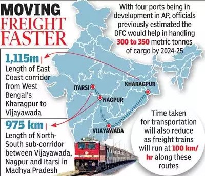
04/10/2023Dedicated Freight Corridor Corporation of India Limited (DFCCIL) will be using Light Detection and Ranging (LiDAR) technique using Laser enabled equipment attached to a Helicopter for carrying out the ground survey for the preparation of the Detailed Project Report (DPR) for the planned 1,115 km East Coast Dedicated Freight Corridor.
This corridor will start from Kharagpur in West Bengal and go through Odisha and end in Vijayawada in Andhra Pradesh. It will connect various cities and towns including Baleshwar, Bhadrak, Bhubaneswar, Visakhapatnam, Nellore, and Vijayawada.
LiDAR Technique
LiDAR (light detection and ranging) technique is a remote sensing technology that uses light in the form of a pulsed laser to measure ranges (distances) to a target. A LiDAR sensor fires off beams of laser light and then measures how long it takes for the light to return to the sensor. When the beam returns, it carries information about the object that it contacted including distance and optical characteristics like reflectivity. It is similar to radar and sonar (that use radio and sound waves). However, it improves greatly on those traditional technologies in terms of the accuracy of sensing.
Advantages of using LiDAR
- Data can be collected quickly and with high accuracy: LiDAR is an airborne sensing technology that makes data collection fast and comes with extremely high accuracy.
- Surface data has a higher sample density: LiDAR gives a much higher surface density as compared to other methods of data collection such as photogrammetry. This improves results for some kinds of applications such as flood plain delineation.
- Capable of collecting elevation data in a dense forest: LiDAR technology is capable of collecting elevation data from a densely populated forest due to its high penetrative abilities. This means it can map even the densely forested areas.
- Can be used day and night: LiDAR technology can be used day and night owing to its active illumination sensor. It is not affected by light variations such as darkness and light.
- Does not have any geometry distortions: LiDAR sensors are not affected by any geometrical distortions such as angular landscapes unlike other forms of data collection.
- It can be integrated with other data sources: LiDAR technology is a versatile technology that can be integrated with other data sources which makes it easier to analyse complex data automatically.
- It has minimum human dependence: LiDAR technology has minimum human dependence since most of the processes are automated. This also ensures valuable time is saved especially during the data collection and data analysis phase.
- It is not affected by extreme weather: LiDAR technology is independent of extreme weather conditions such as extreme sunlight and other weather scenarios. This means that data can still be collected under these conditions and sent for analysis.
- Can be used to map inaccessible and featureless areas: LiDAR technology can be used to map inaccessible featureless areas such as high mountains and thick snow areas.
- It is cheap: LiDAR technology is a cheaper method of remote sensing in several applications, especially when dealing with vast areas of land considering the fact that it is fast and extremely accurate.
How the LiDAR Data is Collected?
A typical LiDAR sensor emits pulsed light waves from a laser into the environment. These pulses bounce off surrounding objects and return to the sensor. The sensor uses the time it took for each pulse to return to the sensor to calculate the distance it traveled. Repeating this process millions of times per second creates a real-time 3D map of the environment. An onboard computer can utilize this 3D map of the surrounding environment for navigation.
LiDAR is used in a wide range of land management and planning efforts, including hazard assessment (landslides, tsunamis, and floods), forestry, agriculture, geologic mapping, and watershed and river surveys. The ground survey is a crucial activity for any infrastructure project as the survey provides accurate details of areas around the alignment. LiDAR survey provides all the ground details and data in 2-3 months against the 10-12 months if it is to be done through traditional survey methods.

